
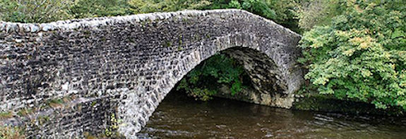
Graceful arched packhorse bridge across the River Ribble.
Dog Hill Brow
Stainforth
North Yorkshire
Stainforth is comprised of two settlements, separated by the River Ribble - Little Stainforth to the west and Stainforth on the east. Stainforth was developed by monks from Sawley (or Salley) Abbey, and was the more prosperous of the two communities.
The name Stainforth comes from the stony ford across the River Ribble which was replaced by the graceful, arched, pack-horse bridge in the 1670s.
Just below the bridge is Stainforth Force, the only significant waterfall on the River Ribble.


By road: Off B6479 and into Dog Hill Brow
By rail: Settle Station then a number 11 bus.
Addison, Sir William, The Old Roads of England, Harper Collins, ISBN 0 7134 1714 5 (1980)
Albert, W., The Turnpike Road System in England 1663- 1840, Cambridge University Press, ISBN O 5210 3391 8 (1972)
Challis, Chris, Packhorse Bridge, Aylestone, T. Savage, ASIN: B0007B7S02 7S02 (1986)
Harrison, David, The Bridges of Medieval England: Transport and Society 400-1800, Oxford University Press, ISBN-10: 0199226857 (2007)
Hartwell, Michael, Illustrated Guide to the Packhorse Bridges of the Lake District, Ernest Press, ISBN-10: 0948153318 (1994)
Hinchcliffe, Ernest, Guide to the Packhorse Bridges of England, Cicerone Press, ISBN-10: 1852841435 (1994)
Lewis, Carenza, Village, Hamlet and Field: Changing Medieval Settlements in Central England, Windgather Press, ISBN-10: 0953863034 (2001)
Williamson, Tom, Shaping Medieval Landscapes: Settlement, Society, Environment, Windgather Press, ISBN-10: 0954557581 (2004)
