
Fine structure that carries the Lancaster Canal over the River Lune
Caton Road, Lancaster
The line of the Lancaster Canal was first surveyed by Robert Whitworth in 1772. In 1791, John Longbotham, Robert Dickinson and Richard Beck re-surveyed the proposed line, with a final survey carried out later that year by John Rennie. The Act of Parliament received the Royal Assent on 11 June 1792 and John Rennie was appointed as Engineer the following month.
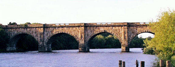
Work started almost immediately on the level pound from Preston to Tewitfield, and in 1794 on the Lune Aqueduct. By 1797 the aqueduct was open, carrying the canal 19 m (62 ft) above the river, and boats were now able to travel the 68.2 km (42.4 miles) from Preston to Tewitfield. In 1813, work began on the canal north from Tewitfield, which was completed to Kendal in 1819. Construction on the 4 km (2.5 miles) Glasson Dock branch began in 1819, and it opened in 1826, with six locks carrying the canal down to the sea.
By 1799, the canal was complete between Bark Hill near Wigan and Johnson's Hillock near Chorley. However, by 1801, no design had even been agreed for the aqueduct over the River Ribble, and in July 1801 it was agreed to build a temporary tramroad to cross the river and span the gap between the northern and southern parts of the canal. The double-track Lancaster Canal Tramroad was opened in 1803 with three steam-worked inclined planes and a low trestle bridge across the Ribble. The canal was extended north from Johnson's Hillock to Walton Summit through a tunnel at Whittle Hills.
This temporary solution became permanent, and the aqueduct was never built. Although this section was the busiest on the canal, income was insufficient to pay for construction of the planned aqueduct.
The tramroad was closed from Bamber Bridge to Preston in 1864, and the remainder to Walton Summit in 1879. The canal between Walton Summit and the Leeds & Liverpool link at Johnson's Hillock was last used in 1932. This section was closed in the 1960s, as a result of the M61 motorway proposal which would have required three bridges over the canal. The Ministry of Transport and British Waterways Board decided that the cost of constructing the bridges was not justified, particularly as the canal was in poor condition, and promoted a bill in Parliament for closure of the canal. As a result, much is now buried under the M61 motorway, and in the Clayton-le-Woods area housing estates have been built on the route in the 1990s. The remainder of the southern end, between Johnson's Hillock and Wigan Top Lock, is now considered as part of the Leeds and Liverpool Canal and remains well used by leisure traffic.
The bridges along the Lancaster Canal were built to a standard design, except where the canal passed through a large estate, such as at Ellel Grange, where the land-owner insisted on having a bridge which he felt was in keeping with the architectural style of his property. The Lune Aqueduct is the most outstanding feature of the Lancaster Canal and is almost certainly Rennie's best work.
The structure is 183 m. (600 ft) long and some 18 m (60 ft)high, with five semi-circular arches supported by huge pillars. Along its top is a deep cornice and balustrades along the parapet. The channel across the aqueduct is semi-circular, and lined with stone over a 1 m clay puddle lining. The bottom of the channel lies 2.3 m (7.5 ft) below the level of the towpath and contains a plug which could apparently be pulled to allow the aqueduct to be drained into the river to allow repairs to be undertaken.
In 1941-42 the by then unused 0.8 km 0.5 miles) section north of Kendal Gas Works was closed because of leakage, and the canal carried its final commercial traffic in 1947. In 1955, an Act of Parliament authorised the closure of the canal. It was drained of water north from Stainton because of leakage, and the last 3 km (2 miles) in Kendal were filled in. However, the route of the canal south from Kendal is still readily apparent, with most of the bridges remaining in place. Construction of the M6 motorway effectively ended navigation north of Tewitfield, with the canal culverted in three places, though it remains in water and can be used by small boats.
A major restoration of the aqueduct was completed in 2012. The structure is Listed Grade II.


By Road: Off A683. Access by flight of steps which rises to the towpath.
Barritt, S., The Old Tramroad - Walton Summit to Preston Basin, Carnegie Publishing, ISBN-10: 01859360580 (2000)
Philpotts, R. Building the Lancaster Canal, Blackwater Books, ISBN-10: 0946623007 (1983)
Rigby, J. The Lancaster Canal in focus, Blackpool : Landy, ISBN-10: 9781872895727 (2007)
Ruddock, Ted, Arch Bridges And Their Builders 1735-1835, Cambridge University Press, ISBN-10: 0521090210 (2008)
Laws, J. & Lancaster Canal Trust, The Complete Guide To The Lancaster Canal, Lancaster Canal Trust, ISBN 978-0-9514146-6-8 (2022)
Satchell, J. Kendal's Canal : History, Industry and People, Kendal Civic Society, ISBN-10: 0950986917 (2001)
Swain, Robert, A Walker's Guide to the Lancaster Canal, Cicerone Press, ISBN-10: 1852840552 (1989)
Tomlinson, Victor I. The Manchester Bolton & Bury Canal, The Manchester Bolton & Bury Canal Society (1991)
Willis, K.G., Garrod, G. and Dobbs, I. The Value Of Canals As A Public Good: The Case Of The Montgomery & Lancaster Canals, Countryside Change Working Paper, University of Newcastle upon Tyne (1990)
